
Beaverhead 100k
Sat July 11, 2026
Date: Saturday July 11th, 2026
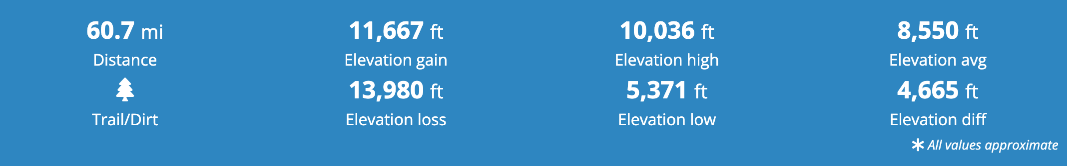
Distance: 62.1 miles
Ascent/Descent: 12,700 ft/15,100 ft
Elevation: Max 10K ft., Min 5.5K ft., Avg. 8.5K ft
Terrain: 59% single track, 35% ATV double track, 6% boulder/skree
Cost: $230
Registration closes: when filled or by June 15, whatever comes first.
Registration includes: a unique running shirt, post race meal, finisher license plate, and custom finisher hoodie.
Qualifications: To be able to run the 100K, runners must have completed a 50K distance (or greater) race in the past 3 years (from January 1, 2022 to July 1, 2025).
Race Start: 4:00AM, Bannock Pass
Finishers receive: a custom LICENSE PLATE and a CUSTOM HOODIE.
An added registration site processing fee of approximately 6% + $1.00 is added during registration.
COVID19 Guidelines
If necessary, COVID19 guidelines will be implemented according to local government and additional race related requirements.
Before you register:
Read and UNDERSTAND the REFUND POLICY
Read the “IS THE 100K FOR YOU?” document
Beaverhead 100k Race Route, Elevation Profile, and gpx File
Click center of map to active.
To move map hold down control button and drag mouse
CLICK HERE to access full screen map.
Course Overview
The race starts at 4:00 AM at Bannock Pass (11 miles east of Leadore ID on Hwy ID-29, 56 miles south west of Dillon MT on Hwy MT-324).
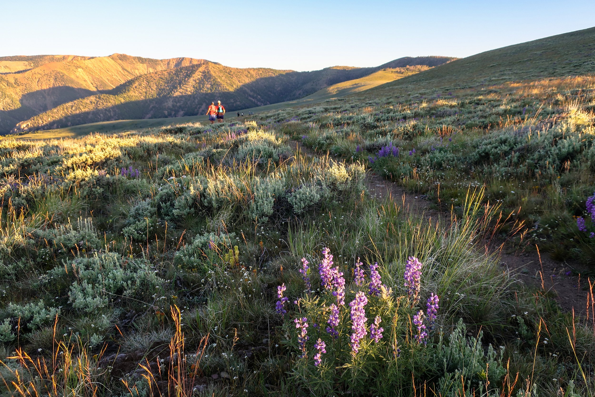
The course from the start to mile 49 is on the Continental Divide National Scenic Trail (CDT). The CDT is on or very near the Continental Divide from the start to mile 49. The length of Continental Divide covered in this event also represents the boarder between Idaho and Montana. At mile 49, runners will leave the official CDT for the remainder of the course, but will continue along the true Continental Divide border for another 5 miles (mile 54). FYI, at mile 49 the CDT dips into Montana then turns parallel to the Continental Divide in-order to divert away from a section of hard to navigate terrain consisting of high mountains, skree, and cliffs. We as masochistic trial running RD’s think you should experience some of the beautiful skree fields but not the cliffs, so we will drop off the Continental Divide at mile 54 and descend into the head waters of Bohannon Creek and onto the finish line.
Because you are following the Continental Divide [separation between drainage to the Pacific Ocean (Idaho side) and Atlantic Ocean (Montana side)] you will always be high in the mountains following the natural elevation changes along the divide and will not ascend or descend into the deep creek and river valleys that boarder the course, except when you drop off the divide to the finish. Because of this, the entire race is at a high elevation with respect to this part of Idaho and Montana. This course has a good mix of terrain, with a mix of climbs, descents, smooth trail and technical sections.
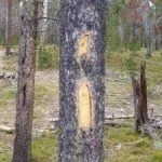
The course is easy to follow. The first time we (the RD’s) covered the entire course on a reconnaissance run we did not get lost. The main reason for this is that there exists good official CDT signage. The official signage consists of CDT signs on trees and posts, the “i” mark on trees (note the new and old variations), and Rock cairns. On some parts of the course they help mark the trail and the Continental Divide near the trail. Besides these abundant existing markings, we will use additional yellow flagging to ensure that the course is clearly marked.


Aid Station Information
Aid station to aid station data: 100K Data Table
See the the Google course map links below for aid station locations.
Aid stations will be well stocked with typical ultra-running food, water, Gu gels, and Tailwind hydration products.
We suggest runners understand their hydration needs and plan to carry the required water volume based on distances between aid stations. In your training keep track of pace, distance, air temperature and water consumption to help you be prepared. It is better to pack around to much water than not have enough.
Packet Pickup & Check In
The packet pick-up will take place from 4:00 PM to 6:00 PM on Friday July 11th at the Salmon City Park (On Hwy 28 south of Salmon next to the softball fields and golf course). A pre-race meeting will take place at 6:00 PM following packet pick-up at the same location. For those who cannot make it to the packet pick-up in Salmon, you can pick up your packet at the finish line.
Bib Rules
You will receive your race bib the packet pickup. It is to be worn on the front of you body and must be clearly visible al all times.
All runners must check in at the starting line.
All runners who do not will be disqualified. Allow yourself at least 30 minutes to check in before the race starts.
Drop Bags
Drop bag service will be available for the 100K runners at Lemhi Pass AS and finish line. Drop bags can be dropped off at the pre-race check-in/meeting or at the start lines on race morning. Please remember to get your drop bags at the finish line (Available after race through Sunday evening the next day). We do not mail drop bags or other left Items after the race.
Pacers
This is a no pacer race. This is not big deal though, think of it this way: At most 100 mile events, you would not be picking up a pacer until around mile 60; by the time you reach mile 60 in this race you are almost done.
Cutoffs (3)
1. Cutout AS (mile 38) @ 2:30 PM (10 hrs 30 mins); 2. Goldstone AS (mile 46) @ 5:30PM (13 hrs 30 mins); 3. Janke Lake AS (mile 50.5) @ 7:30 PM (15 hrs 30 mins). Runners must check out of these aid stations before the cutoff time or they will be pulled from the course and taken to the finish line with the aid station personnel. The cutoffs are for the safety of the runners and will be strictly enforced.
A head lamp and/or flash light is recommended for those who will be at the Janke Lake AS at 4PM and later. Picking up a light source in a drop bag or from crew at Lemhi Pass is advisable. There is no finish line cutoff, but runners must check out of the Janke Lake AS by 7:30 PM to finish.
Distance Changes
We realize there are often reasons to change race distances after you have registered. Click here for Instructions to change events.
Runner moving from 100K to 55K will not receive a refund in registration fee difference.
No distance changes can be made after June 15th.
Start and Finish Line Shuttles
Options:
Start Line Shuttle – From Stagecoach Inn Parking Lot to Startline at Bannock Pass ($30/person)
Finish Line Shuttle – From Finish to Stagecoach Inn Parking Lot ($15/person)
No shuttles provided from finish to start lines. Runners who drive to start lines must arrange to have their vehicles taken to the finish or Salmon.
Specifics:
Start line shuttle cost ($30/person)
Finish line shuttle cost ($15/person)
Shuttle ticket costs are non-refundable. If you drop from the race or no longer need the shuttle we are unable refund the fee. Shuttles are critical to the success of this race and due to limited capacity in Salmon procuring services early in the year is critical, this has a large up front cost.
Start line shuttle tickets must be registered and paid for by June 15 (paid at registration on RunSignup OR at the store (click here for instructions to buy tickets post registration). No start line shuttle tickets can be purchased after June 15. Finish line shuttle tickets can be purchased up to race day.
There is temporary space available at the 100K starting line for families and crews to drop off runners and watch the start of the races.
There will not be transportation back to the start locations to pick up vehicles.
100K Shuttle Departure Time: 2:15 AM, To get more sleep, we recommend you get one of the few hotel rooms in Leadore or dirt bag camp (no ground fires!) at the start line.
There will be parking available for runner families and crews at the finish line.
The distance from the finish line to Salmon is about 10 miles and travel time is approximately 20 minutes.
Crewing
There are some AS’s accessible to crew and family/friends. The access depends on the race you are in. We ask all runners to instruct their crews to follow these rules. It is critical that they do so to maintain our permits. This is so critical that failure to follow the rules will lead to the DQ of the runners who’s crews break them. We do not like to use such language but we have too in order to maintain our race status. In past years this was not as critical, but with our current race numbers we have to enforce them. Here are the Crewing Rules:
100K runners can be crewed at Lemhi Pass AS, Warm Springs AS, and Cutout AS. Cutout AS is on a narrow mountain road that cannot handle the traffic load that will occur with 55K runner crews due to its closeness to the start (runners to close together). Because the 100K runners are more spread out and due to its proximity to Warm Springs AS, 100K crews will be able to drive directly to Cutout AS after crewing at Warm Springs AS, crew their runner then leave with traffic being spread out.
At Lemhi Pass (mile 27), you are allowed to park on the side of the road (pull into grass with one side of wheels), but YOU CANNOT DRIVE whole vehicle INTO THE GRASS/SAGEBRUSH AREA.. THE US Forest Service and BLM will be enforcing this.
After leaving Warm Springs AS heading north, in a few miles you will see a sign on the side on the edge of Warm Springs Road showing the access road to Cutout AS.
100K crew members at Cutout are to pass the AS (can be seen from the road) turn around in the small cutout (on the left side of road 200 ft past AS) and park on the side of the road facing out, far enough off the road to allow others by. As soon as your runner has left the AS, please exit.
Although the roads are not super technical, a 4WD or AWD is recommended.
Drive slowly and carefully.
It is the runners responsibility to inform their crew of these rules.
To help reduce traffic and manage flow we ask that crews accessing Lemhi Pass via the Idaho side (Hwy ID-28) enter via Agency Creek RD (Hwy ID-28 at Tendoy, ID) and exit via Warm Spring RD (links to Hwy-28 at 17-mile) [see map below]. For crews accessing Lemhi Pass via the Montana side, enter via Lemhi Pass Rd and, if going tho the finish line, use the Warm Springs RD to exit to ID Hwy-28. The Agency Creek Rd, Lemhi Pass Rd, and Warm Springs Rd are mostly gravel and well maintained. Two-wheel drive vehicles can drive these roads. Please obey all speed limits and drive extra slow around Lemhi pass; runners and people will be on the road.
100K Google Map Aid Station and Finish Line Directions
Hwy 28 (Leadore ID) to Bannock Pass (Start Line). https://goo.gl/maps/dUsyAmV98VS325cj8
Hwy 28 (Tendoy ID) to Lemhi Pass AS. https://goo.gl/maps/nruDZse5DgsHfieQ7
Lemhi Pass AS to Warmsprings AS. https://goo.gl/maps/kG5y8LXfEYWK97N6A
Warmsprings AS to Cutout AS. https://goo.gl/maps/eS5bjoz6YHwkB9S9A
Cutout AS back to Hwy 28. (DO NOT go back up route to Lemhi Pass and down Agency Creek Rd). https://goo.gl/maps/JAjK5BD8ZJEiEDQC7
Hwy 28 (Geertson Creek Rd) to Finish Line. This route only takes you to the cattle guard. Google maps will not allow us to extend the route up to the finish line. Cross cattle guard and follow road over bridge and up to finish line (Drive Slow). https://goo.gl/maps/KExnyngvag2JL4co6